

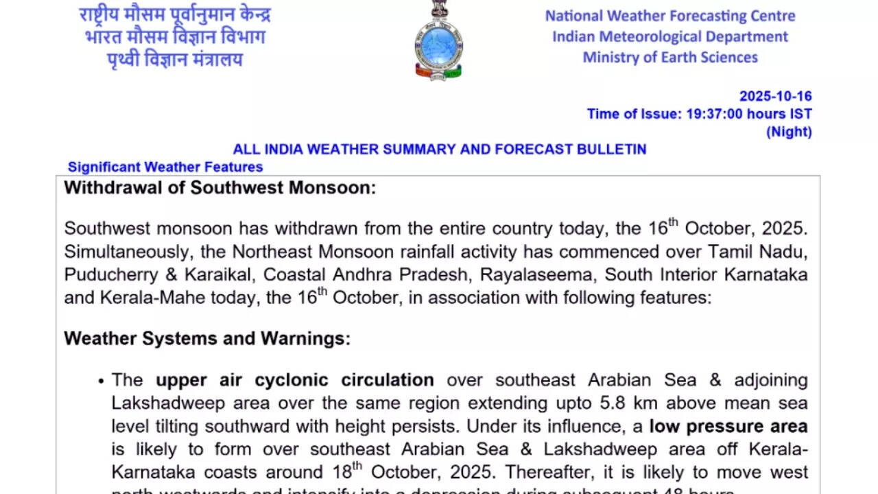
In a significant seasonal development, the India Meteorological Department (IMD) has officially declared the complete withdrawal of the southwest monsoon from the entire country as of October 16. This marks the end of an active rainy season, and what does that actually mean? Does it mean no more rain for this year? According to the IMD’s All India Weather Summary and Forecast Bulletin issued late Thursday evening, “Southwest monsoon has withdrawn from the entire country today, the 16th October, 2025.” With the southwest monsoon exiting, the northeast monsoon has already started influencing weather patterns over Tamil Nadu, Puducherry and Karaikal, Coastal Andhra Pradesh, Rayalaseema, South Interior Karnataka, and Kerala-Mahe.Meteorologists are closely monitoring an upper air cyclonic circulation over the southeast Arabian Sea and adjoining Lakshadweep region. Under its influence, a low-pressure area is expected to form over the southeast Arabian Sea and Lakshadweep, off the Kerala-Karnataka coasts, around October 18. The IMD forecasts that this system could intensify into a depression within 48 hours, resulting in stronger winds and heavier rainfall.
Southern India braces for heavy rains and thunderstorms
Heavy to very heavy rainfall is likely at isolated places over Kerala and Mahe, Lakshadweep, and Tamil Nadu, Puducherry and Karaikal on October 17-22. Andhra Pradesh and Karnataka are also expected to witness heavy showers during this period, with moderate rainfall continuing at many places.
Thunderstorms accompanied by lightning and gusty winds reaching speeds of 30–40 kmph are expected over Kerala, Tamil Nadu, Puducherry, Telangana, Coastal Karnataka, Odisha, and the interior parts of Karnataka over the next five days. Lighter thunderstorms are also possible in isolated pockets of Andhra Pradesh, Konkan and Goa, parts of Maharashtra, and north interior Karnataka.Western India may experience lightning activity over Konkan and Goa on October 17 and central Maharashtra from October 18–20. Meanwhile, northern and central India are likely to remain dry, with only isolated showers over Assam, Meghalaya, and West Madhya Pradesh.Temperature readings reflected the seasonal transition, with minimum temperatures remaining markedly above normal, over 5 degrees Celsius higher than average, in isolated locations across Assam, Meghalaya, and Bihar. The lowest temperature in the country was recorded at 13.5 degrees Celsius in Una, Himachal Pradesh, while the highest, 36.9 degrees Celsius, was noted in Barmer, Rajasthan. The national capital woke up to a hazy yet pleasant morning, with temperatures hovering around 21 degrees Celsius, marking a mild and comfortable start to the day. As per the latest forecast, Delhi’s daytime temperature is expected to rise gradually, peaking at around 31 degrees Celsius during the afternoon hours before dipping again in the evening. Despite clear skies and dry weather conditions, a persistent layer of haze continues to blanket the city, also hinting at the early onset of the pollution season.According to the India Meteorological Department (IMD), the weather in Delhi is expected to remain mostly clear in the coming days, with no chances of rain. Minimum temperatures have started to fall, with Thursday recording 18.1 degrees Celsius, the lowest so far this season.However, alongside the pleasant chill, the air quality has taken a sharp downturn. The Air Quality Index (AQI) has slipped into the ‘poor’ and ‘very poor’ categories across several parts of Delhi and the National Capital Region (NCR). The worsening conditions are attributed to calm winds, and stable atmospheric layers, and increasing emissions from stubble burning in neighbouring states..Authorities have already initiated measures under the Winter Action Plan to combat pollution in the capital. These include tighter monitoring of vehicle emissions, and restrictions on waste burning.