

The India Meteorological Department (IMD) has predicted a sustained spell of widespread rainfall across southern India over the next several days, with isolated very heavy to extremely heavy showers expected in Kerala, Tamil Nadu, coastal regions of Andhra Pradesh, and Karnataka. The ongoing activity is attributed to a well-marked low-pressure area over the southeast Arabian Sea and adjoining Lakshadweep region, which is likely to intensify into a depression within the next 24 hours.According to the IMD’s latest bulletin, light to moderate rainfall accompanied by thunderstorms and lightning is expected in many parts of Tamil Nadu, Puducherry, Karaikal, and Rayalaseema till October 21, gradually extending to Kerala, Mahe, Lakshadweep, and coastal Karnataka by midweek. The weather department has also warned of strong surface winds ranging between 30–40 kmph, particularly over south interior Karnataka on October 24 and 25.
Southern India braces for intense rainfall spell
The IMD’s extended range forecast highlights an active monsoon transition phase across the southern peninsula, with a combination of synoptic systems and sea-surface circulations fueling persistent rainfall activity. The forecast suggests that very heavy rainfall is likely over Kerala and Mahe on October 20, and again from October 23–25, while Tamil Nadu and Rayalaseema could experience intense showers from October 22 to 25.The weather activity is also expected to extend to coastal Andhra Pradesh, Yanam, and Lakshadweep, where multiple rounds of very heavy rainfall may occur through the week. The IMD cautioned that continuous heavy rain could trigger localised flooding, riverine overflow, and landslides, especially in districts with steep terrain and water-saturated soil.The IMD explained that multiple meteorological systems are currently influencing the weather pattern across peninsular India.At 5:30 p.m. IST on Sunday, the well-marked low-pressure area over the southeast Arabian Sea and adjoining Lakshadweep region was moving west-northwestwards, and is likely to intensify into a depression within the next 24 hours. The system is expected to bring intense rainfall, squally winds, and rough sea conditions to the Kerala and Karnataka coasts during this period.Simultaneously, an upper air cyclonic circulation persists over the south Andaman Sea and adjoining Bay of Bengal, which is likely to evolve into a low-pressure area around October 21. According to the IMD, the system may intensify into a depression over the south and central Bay of Bengal by October 23, potentially enhancing rainfall over the east coast of India, including parts of Odisha, Andhra Pradesh, and Tamil Nadu, during the latter part of the week.
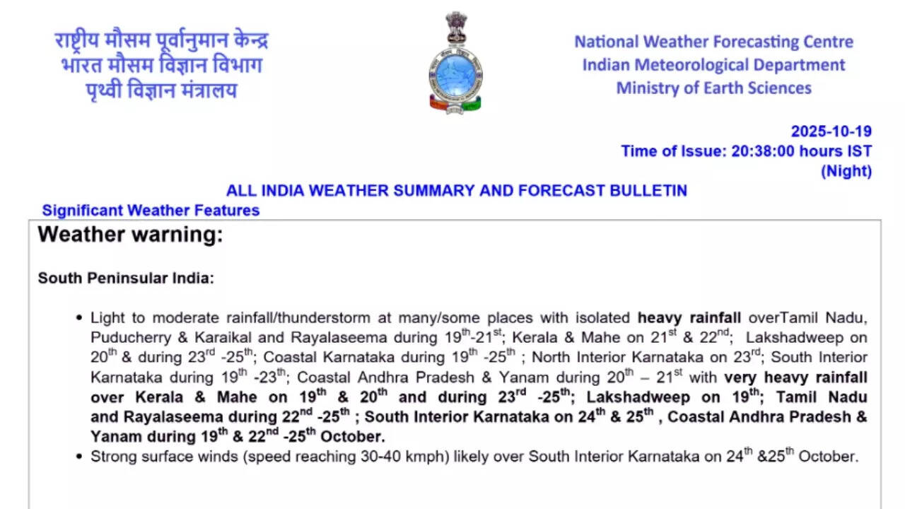
Forecast: Heavy rainfall, thunderstorms, and squally winds
October 20
- Very heavy rainfall is likely over Kerala and Mahe, while heavy rainfall will occur in Andaman & Nicobar Islands, Andhra Pradesh, and Tamil Nadu.
- Squally weather with wind speeds of 35–45 kmph (gusting up to 55 kmph) will persist along the Kerala–Karnataka coast and over Lakshadweep.
October 21
- Rain and thunderstorms will continue over Andaman & Nicobar Islands, Andhra Pradesh, Tamil Nadu, Coastal Karnataka, and Kerala.
- The developing Bay of Bengal system will begin influencing rainfall along the eastern coastline.
October 22–25
- Very heavy rainfall is expected over Andhra Pradesh, Tamil Nadu, Kerala, and Karnataka, with widespread thunderstorm activity.
- Squally winds are expected to intensify over the south and central Arabian Sea, and later over parts of the Bay of Bengal.
While southern India continues to experience intense rainfall, north and central India have remained largely dry under clear skies. The IMD observed that minimum temperatures were 5 degrees Celsius above normal in isolated pockets of Assam, Meghalaya, Bihar, and Uttar Pradesh, while the maximum temperature touched 37.5 degrees Celsius in Barmer (Rajasthan), the highest in the country.
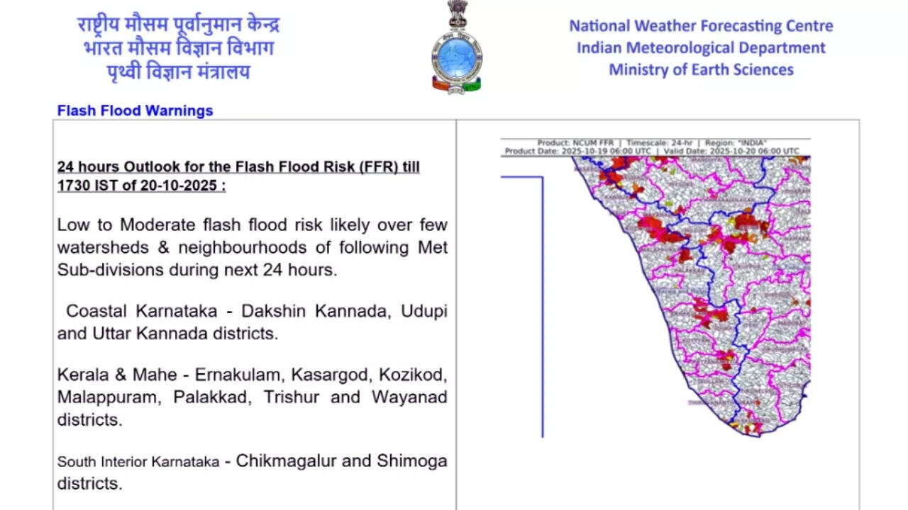
Flash flood warnings for vulnerable districts
The IMD’s Flash Flood Guidance (FFG) system has identified a low to moderate risk of flash floods in several districts across Kerala, Karnataka, and Tamil Nadu due to continuous rainfall and saturated soil conditions.
- In Kerala, the risk zones include Ernakulam, Kozhikode, Malappuram, Palakkad, Thrissur, Wayanad, Kasaragod, and Idukki.
- In Karnataka, the vulnerable districts are Dakshina Kannada, Udupi, Uttara Kannada, Shivamogga, and Chikmagalur.
- In Tamil Nadu, the IMD has listed Coimbatore, Nilgiris, Erode, Tiruppur, and Dindigul as potential flood-prone areas.
The IMD also warned of surface runoff, river swelling, and waterlogging in urban areas, as well as the risk of landslides and mudslides in hilly terrain.Looking ahead, the IMD expects fairly widespread to widespread rainfall activity to persist across the southern peninsula through the upcoming weekend. The rainfall is likely to remain concentrated over Kerala, Tamil Nadu, Karnataka, and Andhra Pradesh. Meanwhile, eastern and northeastern India, including Odisha, Chhattisgarh, Mizoram, and Tripura, may experience scattered showers and thunderstorms due to moisture inflow from the Bay of Bengal.